Urban heritage · Olinda / Carmo
São Francisco Fort — Cheese Fort

A small fort nicknamed after cheese
The Fortim de São Francisco is known in Olinda as the Fortim do Queijo, the cheese fort, a nickname earned precisely by its small size. The first records of the fort or bastion of São Francisco date from the seventeenth century.
It is the clearest point for understanding coastal defence logic: until the 1730s the little fort served to protect the shore, after which it was abandoned.
Its present appearance comes from restoration carried out between 1973 and 1977, so this is a recovered monument rather than a conserved ruin.
Come for the scale and the siting, because a small fortification by the water explains what coastal defence looked like between the major forts.
It is also one of the few places in Olinda where history appears without interiors or display cases, only the structure and the shore.
A practical frame: the object is small and its meaning comes from how it sits in the town rather than from size. Olinda is a rare case where ordinary infrastructure and utilitarian buildings survived alongside the churches, and that completeness is what sustains the World Heritage title.
The seventeenth century, the 1730s, 1973-1977
The first records of the São Francisco fort are from the seventeenth century, when the coast of Pernambuco was contested by European powers and fortified from both sides.
Until the 1730s the little fort performed its task of protecting the shore and was then abandoned, because the maritime threat changed and small works lost their purpose.
Between 1973 and 1977 restoration gave the structure its present features, part of the Brazilian wave of colonial heritage works in that decade.
Later the surrounding area was redeveloped, which changed the approaches and the monument's relation to the seafront.
The three stages, defence, abandonment and restoration, read on site almost without explanation. Note that dates of construction, consecration and completion often diverge in Brazil, and official sources may give different years for the same property.
What the fortification is
The structure is compact, and its size is what earned the nickname: compared with the great forts of Recife it really is small.
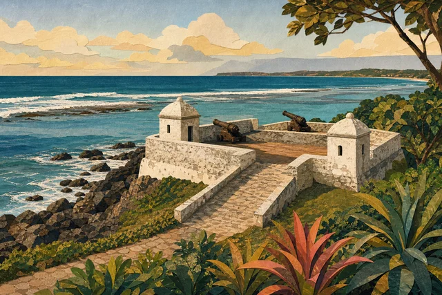
The construction is utilitarian, with walls, a platform and an orientation towards the water, all subordinated to firing on a seaward approach, with no decorative programme.
After the 1970s restoration the work reads as a whole, but remember that part of the fabric results from restorers rather than original masonry.
There is no display inside: the content of the visit is the structure, the shore and the view.
The surrounding area works as public space, which changes the feel, because the monument lives inside the everyday city.
Remember the climate: humidity, salt and heavy rain degrade materials faster than in temperate zones, so the condition of anything here results from continuous care.
How to look closely
Judge the dimensions, because comparing this fort with the Cinco Pontas and Brum forts in Recife immediately explains the difference between a main fortification and an auxiliary point.
Look at the orientation of the platform and imagine the field of fire, since the siting followed the geometry of the coast and its approaches rather than convenience.
Look for marks of restoration, because differences in masonry and material between original and recovered stretches are usually visible.
Notice how the structure relates to today's seafront, since redevelopment changed the approaches and the monument now stands inside a promenade area.
And look at the sea, from which the threat was expected, because the view belongs to the historical content. Watch the limits of intervention: where restoration stopped, what was left as found and what was deliberately not rebuilt for lack of documentary evidence.
Olinda's shore
The little fort stands by the coast, away from the climb into the historic centre, so it fits a walk along the water better than a route of churches.
Around it are the seafront and housing, with ordinary urban life and no souvenir trade.
From here you can continue to the beaches or climb to the upper town, but the ascent is real and deserves its own planning.
At weekends the seafront comes alive and the monument sits within the flow of strollers.
In the evening the area is quiet, with modest lighting.
Note that distances deceive because of the terrain, and a route works better organised by altitude than by metres.
Colonial defence and its cost
Coastal fortifications protected the export economy: sugar left by sea, and any threat to shipping struck the revenue of colony and metropolis alike.
It is worth remembering who built such works, because in colonial Brazil much construction labour fell to enslaved people whose names barely appear in the records.
Abandonment after the 1730s shows that monuments also vanish through changes in military geography rather than only through war.
The 1970s restoration returned the structure to urban use within a policy that was beginning to link heritage with tourism.
Looking at the fort with both the defensive task and the labour that achieved it in view is the honest approach. Remember that World Heritage status brings attention and funding but also raises the cost of living for permanent residents.
Planning the visit
Allow twenty minutes: the structure is small and its meaning reads quickly, especially if you have already seen the large forts of Recife.
Come in the morning or late afternoon, because there is almost no shade and the open ground heats up.
Combine it with a walk along the seafront and the beaches of Olinda rather than with the churches of the upper town.
If fortification is your subject, plan the Cinco Pontas and Brum pair in Recife on another day.
There is no infrastructure on site, so bring water.
Build a day of three or four stops with pauses, because trying to see more ends in fatigue.
Getting there and access
The little fort lies on Olinda's seafront, about seven kilometres from central Recife. You can arrive by taxi or by bus with a walk along the shore.
The area is open and relatively level, which eases the approach, but the structure is historic, with changes of level and steps.
The surrounding paving improved with redevelopment, though stone is slippery in the rain.
Parking along the seafront is limited, especially at weekends.
There is no shade, and at midday the visit is harder than it looks. Plan your return in advance, because transport is harder to find in the historic part after dark.
Where to go next
The immediate continuation is Olinda's seafront and beaches right beside it.
The lighthouse on Morro Serapião continues the maritime line of the town and sits in the same area.
The historic centre offers the Alto da Sé, the convents and the markets, but the climb deserves separate planning.
To complete the fortification theme, visit the Brum fort in old Recife and the Cinco Pontas fort in São José.
And sunset repays more on the shore, with the town's silhouette behind you.
Olinda repays two short days more than one long one, because the town is small and dense.
Verified facts
Every fact below is linked to this profile’s source codes.
- Location
- Carmo · Olinda OLINDA_MON
- Listed address
- Rua do Sol OLINDA_MON
- Documented focus
- Small coastal fortification of 17th century origin, with a ramp, guard houses and cannons aimed at defending the coast. OLINDA_MON
- Evidence basis
- Identity, location and cultural relevance are supported by primary evidence. OLINDA_MON
Original Meu Recife editorial copy based only on this profile's source codes. It does not reproduce third-party text in full or turn a community-guide opinion into fact.
Before visiting
The structure is small and twenty minutes is enough, because its meaning reads quickly, especially if you have already seen the large forts of Recife. There is almost no shade and the open ground heats up, so come in the morning or late afternoon and bring water. It pairs better with a walk along the seafront than with the climb to the upper town.
- Reference address
- Rua do Sol, Carmo, Olinda — PE
- Urban heritage
- 30–90 min
- What can change
- Hours, tickets, accessibility and temporary closures can change. Confirm with the official source before visiting.
Getting there
Coordinates cross-checked against multiple mapping sources
- Reference address
- Rua do Sol
- District and city
- Carmo · Olinda, PE
- Verified coordinates
-8.015833, -34.846320